Grizzly Bear Scat

Grizzly Bear Scat

We arrived at the ranger Station in Wrangell-St Elias National Park, Alaska. As we checked in for our backpacking trip to Dixie Pass, an older looking ranger eyed me. After a brief conversation, he asked, “Do you know what grizzly bear scat looks like?” I shook my head no. 

Six months before meeting that ranger, Cathy turned 40 years old. We decided to celebrate her milestone birthday in Alaska the next summer and do some backpacking while there. Coincidentally, Cath’s sister Bonnie was marrying Don that June and they asked about coming with us for their honeymoon.  We quickly said yes and started outlining the trip.  

While we planned to visit several places, the highlight would be a four-day backpacking trip in Wrangell-St Elias National Park (WSNP). It is a vast national park that is the same size as Yellowstone National Park, Yosemite National Park, and Switzerland combined. Only Denali, also in Alaska, is a larger Park. 

We specifically chose WSNP because of its remoteness. Unlike Denali, which has buses circling the park and regulates when and how people can enter the park, WSNP is a wilderness area with one 60-mile gravel road dead-ending at the town of McCarthy. I should mention that while McCarthy’s summertime population was 200, its winter population was just 13. 

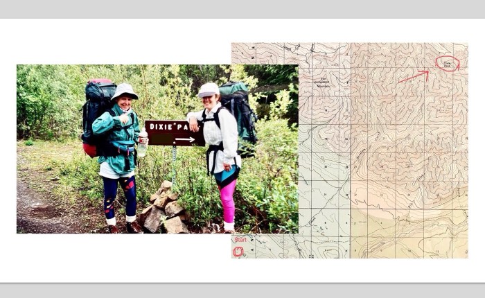
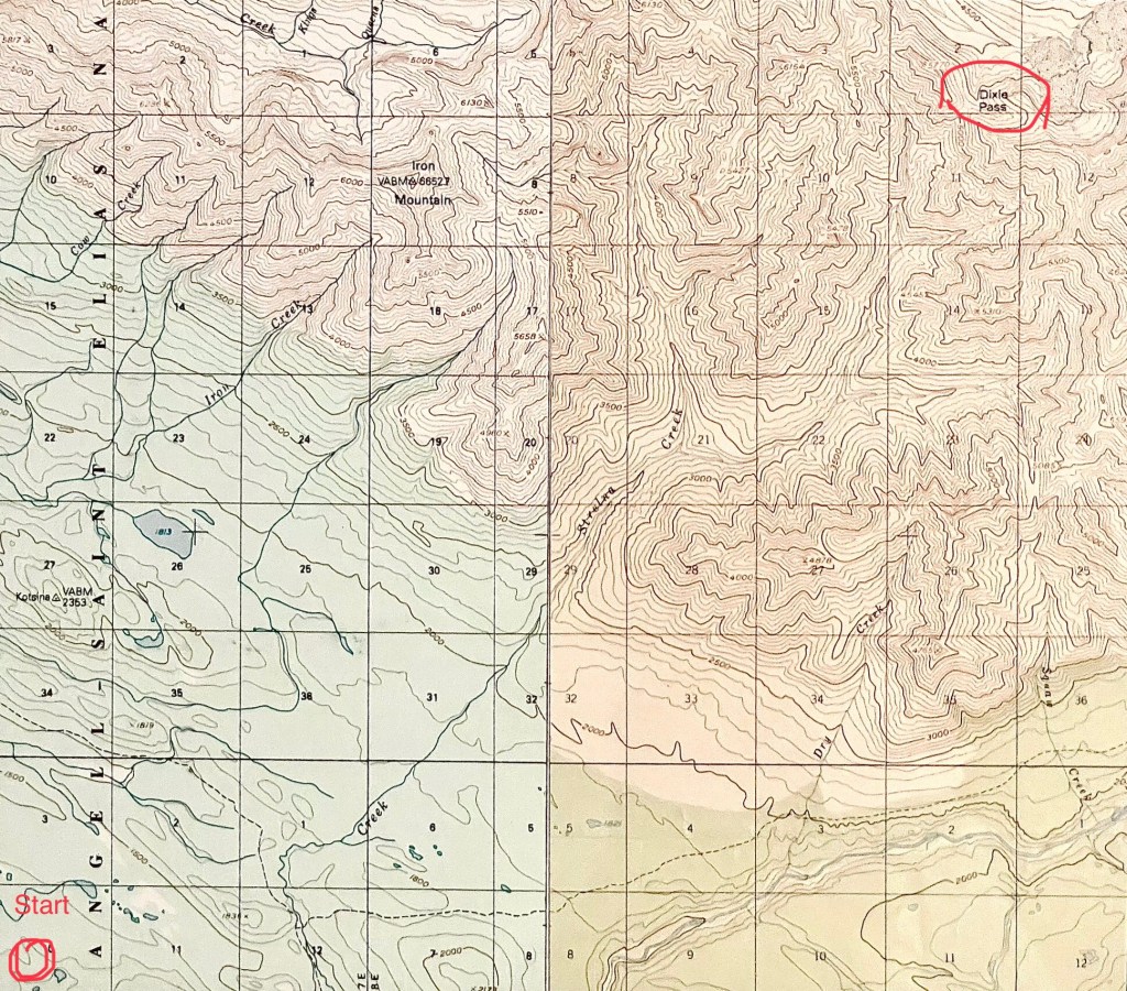
In the WSNP there were no trails, only suggested routes requiring map and compass skills. We eventually settled on a hike to Dixie Pass – a four-day, 28-mile round trip hike with 5,400 feet of elevation gain.  The country was remote and about half the hike was above the tree line.  It was also mosquito infested until you were above the tree line. Guidebooks suggested checking in and out with the Ranger Station at the entrance of the park for safety reasons.   

Part of Our Map for the Hike to Dixie Pass

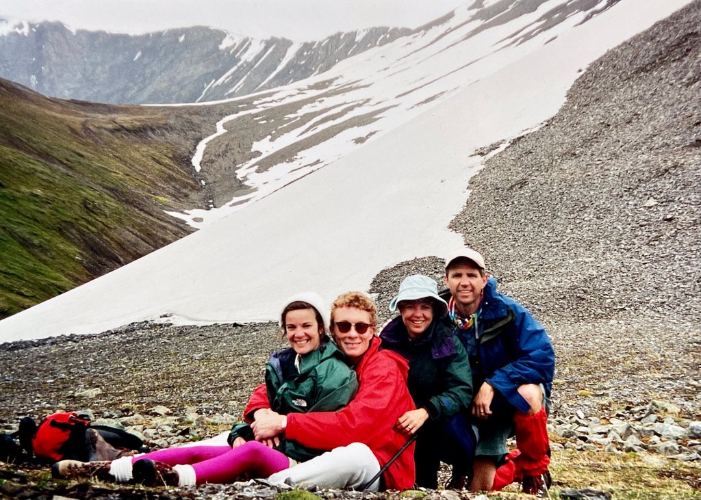
After Bonnie and Don’s wedding in June of ‘96, the four of us flew to Anchorage. We spent a few days seeing some sites and getting acclimated to the near continuous sunlight. Eventually we made our way to WSNP and checked in at the Ranger Station. 

We signed in and spoke with one of the two rangers working that day and told him of our planned hike to Dixie Pass. He gave us a few safety tips and talked about the fact there were both black bears and brown bears (also known as grizzly bears) in the park. While black bears are usually more timid and less confrontational, the grizzly bear was totally different. They could attack even when unprovoked. 

The ranger pointedly looked at us and then asked, “Have you bought any jingle-bells for attaching to your pack to make noise, so the bear know you are coming?” I answered, “No, we planned to attach our drinking cups to the outside of our packs so they would make noise.”

AhhhhhhDid you bring any pepper spray with you?”   – “Ummm, no. Should we have?”

Hmmmmmmm.  Do you know the difference between black bear skat (poo) and grizzly bear skat?”  – “No, we don’t. Could you fill us in?”

He kind of smiled, and then said, “Sure.  Black bear scat is sort of brownish and fibrous. You’ll often see berries in it as well.  And grizzly bear scat?  Well, it’s similar to black bear scat, but it also has jingle bells in it and smells like pepper!”

A half second passed and then all of us, including the ranger, burst out laughing. He’d reeled me in like a bluegill in a pond. 

After the laughter ended, he did share that in WSNP, unlike Denali, there generally were no bear problems. There were so few people in the park that when the bear smelled or saw humans, they generally turned around or went in a different direction. They didn’t really know what we were and would probably avoid us. If we did come across a bear, stay still or slowly back away, don’t run, and things would probably turn out fine. 

We thanked him for his help and then drove down the gravel road awhile before turning onto a dirt trail for a bit. Eventually, we arrived at a small, cleared area. We saw a small sign pointing towards Dixie Pass.  There were no other cars. 

Cathy and Bonnie at the Start of the Hike.

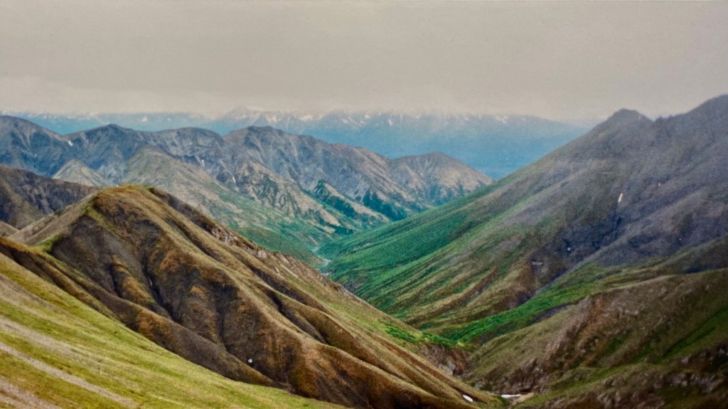
The hike itself was wonderful and everything we hoped for – beauty, silence, wilderness – Mother Nature at her best.

We definitely needed a map and compass to guide us, so both Boy Scout and Army skills came in handy. Mountains, valleys, creeks, draws, outcroppings … they all became important in identifying our route.

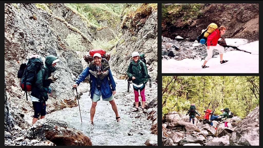
The mosquitos were horrible until we climbed above the tree line.  A half mile into the hike, we needed our head nets and sprayed ourselves with 90% Deet. We used so much Deet, Cath’s running tights basically disintegrated when we returned home and she washed them. 

Cathy and Bonnie in Their Mosquito Netting, While Holding a Moose Antler.

The route challenged us. There were multiple creek crossings, some two feet deep, and places where we hiked over snowpack. We switched to Tevas or sandles several times each day to keep our boots dry. There was also plenty of rock hopping where you were using both legs and arms to scramble over the boulders. While not really dangerous, the trail wasn’t for the faint of heart.

Creeks and Snow and Boulders, Oh My!

We finally arrived at Dixie Pass where there were gorgeous views in all directions. We lounged around, ate lunch and took some photos. Although it was June 30th, we were snowed on while hiking back down from the pass. 

View From Dixie Pass Looking Back at our Approach Route.

On the 3rd morning around breakfast time, we did have a distant encounter with a brown bear, but the ranger was right. When the grizzly smelled us, he turned in another direction and gave us a wide berth. We were probably 75 yards or so away and watched him from a hillside. Still, I have to say it elevated my pulse.

Eventually, we finished the hike and our grand adventure ended. It was both a beautiful and challenging hike – one of those life events you never forget.  For me, the story is never complete without also talking about the ranger, the jingle bells and the pepper spray. I laugh to this day when I tell the tale, and it always gets a chuckle. 

Bonnie, Don, Cathy and I at Dixie Pass.

The Hike

The Hike

As we hiked towards the Hanakapi’ai Falls on Kauai, what I was thinking was “If one more person happily says to meYou’re almost there!’, I am going to punch them.” Seriously. Bonnie and I knew we were almost there, but I was concentrating on climbing over boulders, roots and slippery rocks, and not falling down…again.

Bonnie, my sister-in-law, contacted Cath and I to see if we were interested in a couple of hikes while visiting Kauai, one of the Hawaiian Islands, with her and her daughter Lana. The hike to Hanakapi’ai Falls sounded interesting, although not for the faint of heart. Bonnie had completed the hike several years earlier with her husband Don, before he passed away. She warned us the trail was a challenge – It’s an eight mile round trip trek with mud, lava rock, roots and stream crossings, with over 1,800 ft of elevation change. It also promised a tropical forest, panoramic ocean views and the Falls themselves, which drop over 400 feet.

The only catch was the rules changed since her last visit – now you needed reservations for the bus to the trailhead and access to Haena State Park. Both Bonnie and I were in, and she made the reservations.

The big day came for the hike and we packed lots of water, snacks and sandwiches. Our friend John dropped us off at the bus pick-up point. We told him we thought we’d finish between 2 and 3PM, and would call once we returned to the shuttle. That allowed 5-6 hours for the hike, at a 2 miles/hour pace, plus some spare time at the beach and Falls. It seemed like a reasonable time estimate. That was our first underestimation. ;-).

We arrived at the park itself about 9:00AM, where there was a check-in station and we were given more information about the trail. It turned out they’ve now measured the trail multiple times in recent years – it clocks in at 9.2 miles, not 8. Whoops! What’s another mile among friends? We were also warned to leave the Falls no later than 2:00PM to ensure we had enough time to hike the return to the start, where the last bus left at 5:30PM. If you missed the bus, it was a 6 mile stroll back to the parking area.

We started up the trail about 9:15. The first section was two plus miles from Ke’e Beach to Hanakapi’ai Beach. Two miles – easy peasy, right? Well, not quite. The first mile was all uphill, much of it over slick flat rocks. The trail also had a 500 or so foot drop off on the right hand side, which ended in the ocean. Mental note to self: if you fall on the rocks, don’t fall to the right. As we hiked along, we passed some folk, others passed us. One young woman hiked by in flip flops, while chatting with her friends. We eventually reached the high point and were rewarded with beautiful views of the ocean and distant coastline. We stopped and took a couple of pics, before continuing.

The View, One Mile Into the Hike.

From there, it was another mile or so downhill. The slippery rocks mostly disappeared, to be replaced by steps carved into the side of the mountain. You know the kind of steps I’m talking about – too wide, and too high to be comfortable while moving downhill. They were easy enough, but would come back to haunt me on the return trip.

An hour and twenty minutes after starting, we reached Hanakapi’ai Beach which was gorgeous. We stopped for a break and to eat a snack. Sitting for a bit felt good. There were warning signs everywhere about the treacherous rip tides and not to swim here. Evidently every couple of years someone would get sucked out to sea, never to be seen again.

At the Beach. Numerous Signs Warned About the Dangers of Swimming Here.

Around 11, we continued our hike. It looked like well over half of the people we’d seen along the way, including the young lady in flip flops, were staying at the beach, so the number of people on the trail to the Falls thinned out considerably. It would be a little over two more miles to the Falls.

Bonnie brought out her new, never used walking sticks for this part of the hike. After the first half mile or so, the trail narrowed considerably. Flat ground gave way to a tangle of tree roots, mud and lava rocks. It slowed us down as we worked to find a reasonable path on the path. We passed through bamboo stands and dense forest along the way.

There were Lots of Rocks and Boulders on the Trail – Looking for a Path on the Path was a Challenge.

Hanakap’ai Stream was on our left as we made our way up the trail. Along the way, we crossed the twenty foot wide stream three times. We rock-hopped across the stream pretty easily the first two times, but on the third crossing, I slipped and went into the water, banging my shin in the process. Bonnie looked at me and my bleeding shin, and with a smile, changed from her boots to water shoes. She then used her sticks to safely cross.

One of the Stream Crossings.

At this point we were nearing the Falls. The trail was getting more slippery, and we were frequently climbing over wet rocks. I fell another time or two, scraping the same shin I’d already banged up. Bonnie stayed vertical the entire time – I may need to buy a pair of those walking sticks for next time!

This is also when we started encountering the Good Samaritans coming the other way – “You’re almost there!” … “Keep going, it’s worth it!” … “Only 15 more minutes to the Falls!” … and then 15 minutes later, “Only 15 more minutes to the Falls – you’re almost there!” I believe that last one was what made me think I’d punch the next person with words of encouragement … ;-).

We did arrive at the Falls a short time later, and they were beautiful. It made the hike totally worthwhile. Bonnie took a short swim in the pool at the base of the Falls and then we ate lunch – our sandwiches tasted pretty damned good. I looked around at the other people at the Falls taking their breaks – I think almost everyone was a decade or four younger than us. Well younger physically, but maybe not mentally. Having eaten, I was feeling pretty good again.

Bonnie, as we Arrived at The Falls.

After about a half hour break, it was 1:00PM and we started our hike back. We were at the four hour mark from our start that morning and knew we were going to be late returning to John, Cathy and Lana. There was no cell coverage in any case, so nothing to be done for it.

The return hike was the same path we came in on only in reverse. Again we passed a few people, and some passed us. There were three Japanese ladies we hiked with for a while, before eventually passing them for good. Another lady was running to the Falls – we would see her again as she re-passed us a couple of hours later. We crossed the stream three more times, and this time, with the use of one of Bonnie’s walking sticks, I managed to stay dry. Eventually we reached the beach, and took another short break before tackling the last two miles.

A Section of the Trail, Returning from the Falls.

The last two miles? As I said before, Bonnie had done this hike 5 or 6 years earlier and at this point said to me “These next two miles are going to suck!” and we both laughed. Finding humor in the truth is always a good thing. She was right – for me, they were tough. Those steps on the way up were spaced just far enough apart to make me dislike them. The downhill for the last mile over those wet stones and roots, well, my knees noticed every step. And yet, there was also a peaceful feeling of contentment. Maybe we were drawing strength from the trail itself.

Finally, at about 4:30PM, a little over seven hours after we set out, we were back at the start. It had been a great experience, a wonderful hike, and a tiring day. We still had no cell coverage, and couldn’t reach our crew to let them know we were safely back, so we just climbed on the bus for the drive to the parking lot. When we arrived dirty and sweaty at the drop off point, two or three hours later than our “expected time”, they were there waiting for us. There were hugs all around and a return to John’s for a well deserved beer.

Over the next couple of days, my thighs reminded me of what a good time I had. I reflected back on the hike, and a couple of things occurred to me. First, Bonnie and I both encouraged each other along the way, as we traded off the lead at various points. It was a natural back and forth between us. Also, although, I’m the former Boy Scout and Army Airborne trooper, Bonnie was the better prepared. She brought her water shoes and the walking sticks, making for a better and safer hike. Those last couple of miles? She may not have skipped up the trail, but she handled them better than I and my old man knees did.

My final thought? Age truly is a state of mind. Go for the gusto, and enjoy every bit of life you can.

Aloha, Until the Next Time.

Addendum:

  • Talking with locals afterwards, I’ve learned the hike is considered one of the “tougher ones” on the island. I’ve been asked by several folk if I would do it again, and the answer is an unqualified yes.
  • Special Thanks to Bonnie for her contributions of content and editing for this blog. Also a big thanks for suggesting the trail in the first place, and for being such a positive force on the hike itself – it was a blast. Love you sis!
  • You can find more information on the hike here: https://www.hawaii-guide.com/kauai/hiking-trails/the_hanakapiai_falls_trail